|
|

樓主 |
發表於 2015-7-28 09:21:08
|
顯示全部樓層
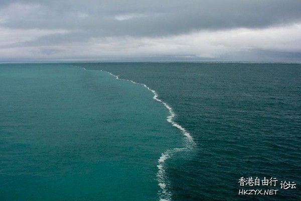
为什么波罗的海和北海相遇海水无法混合?

神奇的发现,原来这张照片一开始就不是波罗的海和北海。。
摘自某老外的blog
I'm sorry to ruin the fun of this but that's a lie. Actually, it's two lies.
First, the Baltic sea and the North sea are both salt water, and salt water is miscible. Being miscible has nothing to do with density. Two liquids of different densities can mix.
Second, the photo wasn't taken where it is said it was; it was taken aboard an Alaskan cruise
我很遗憾的扫兴了,但是这确实是谎言。事实上是两个谎言.
首先,波罗地海和北海都是盐水溶液,盐水和盐水之间是互溶的,和密度无关。两种不同密度的液体可以混合。
其次,这张照片并不是拍自波罗的海和北海,而是拍阿拉斯加的游轮上。(渣翻勿喷orz)。
然后是照片了原作者的解释:
I thought I would clarify the image of the Merging Seas, in fact it is my image I posted on Flickr a few years ago and it has gone viral a few times. I call it 'Merging Oceans'. It was taken on a cruise in Alaska in the Alaskan Gulf, not in the North Baltic sea.
我想我要澄清一下这张并列的海的照片,事实上这是我几年前在Flicker刊物上发表的文章并且它火了几次。我取名为”并汇之海“(渣翻)。这种照片摄于阿拉斯加海湾的一艘游轮上,而不是波罗的海和北海。
到这里我们发现谣言不能怪网友,外国人自己都搞不清还要原作者跳出来解释。。。
那么,这种景观是如何出现的呢?
以下是参考自Quora和mythbusting的答案:
This is an urban legend. The picture shown is not the Baltic Sea and North Sea, and the border shown is not due to salinity gradient. The picture is from Alaska, showing where dirty glacial meltwater was flowing into the open ocean. It's a temporary phenomenon caused by sediment washed into the ocean -- microorganisms thrive on the nutrients. The color is not due salinity.
Waters of different salinity levels will mix quite easily when exposed to disturbances from wind, waves, and current. Salinity separation phenomena like haloclines are only stable in low-energy systems like caves or when constantly regenerated by persistent effects like surface evaporation. In either case, the halocline is a horizontal boundary (eg gravity puts the lighter fluid on top), not a vertical line like is shown in the picture.
这是扯淡。照片并不是波罗的海和北海,而且分界线也不是因为含盐度。照片是摄自阿拉斯加,描绘了融化的冰川水流入海洋。这是一个由进入海洋的沉积物——在营养环境下繁殖的微生物所造成的短暂的景观。颜色的不同并不是由于含盐度。
不同含盐度的水暴露在海风,波浪,洋流中会很容易混合在一起。分层现象如盐跃层 只会在相对低能量的系统中保持稳定,比如在洞穴中。不管怎样,分层现象必然是垂直方向分层而不是水平方向(重力是垂直的)。所以图中水平的分层线是不科学的。
Ken Bruland, professor of ocean sciences at University of California-Santa Cruz, was on that cruise. In fact, he was the one who snapped the pic. He said the purpose of the cruise was to examine how huge eddies -- slow moving currents -- ranging into the hundreds of kilometers in diameter, swirl out from the Alaska coast into the Gulf of Alaska.
Those eddies often carry with them huge quantities of glacial sediment thanks to rivers like Alaska’s 286-mile-long Copper River, prized for its salmon and originating from the Copper Glacier far inland.
肯*布兰特,加州圣克鲁兹分校海洋学教授,在那艘游轮上拍了这张照片。他说那次探查的目的在于研究巨大的漩涡——缓慢移动的洋流,如何扩散数百公里的直径,进入阿拉斯加海岸。
这些洋流经常携带大量的冰川沉积物,这些有鲑鱼和库珀冰川留下的沉积物来自诸如库珀河之类的河流。
“They do eventually mix, but you do come across these really strong gradients at these specific moments in time,” he said. Such borders are never static, he added, as they move around and disappear altogether, depending on the level of sediment and the whims of the water.
”他们最终确实会融合在一起,但是你能看见了这些奇观因为你来对了时候。“他说道。这样的分层从来都不会稳定,他补充道,因为其移动和消失同时发生,取决于其所含的沉积物和水的流动。
|
|
